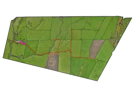



Drone Mapping a Wairarapa Hill Country Station
Maplands completed a full drone survey of a 3,200-hectare Wairarapa station, producing high-resolution orthomosaics and terrain models to support farm planning.
Project Overview
A large Wairarapa hill country station needed accurate terrain data and full-property aerial imagery for infrastructure planning and an upcoming LUC assessment.
Maplands completed a multi-day drone survey across the 3,200-hectare property, delivering high-resolution orthomosaics and a digital elevation model in GIS-ready formats within three weeks.
Client Objectives
The engagement was guided by clear, measurable objectives that defined success for both business leadership and IT operations.
Full Property Coverage
Survey the entire property including steep and remote areas inaccessible by ground.
High-Resolution Imagery
Produce orthomosaic imagery for farm management and land use planning.
Digital Elevation Model
Generate an accurate terrain model to support infrastructure and LUC planning.
GIS-Ready Outputs
Deliver all data in GIS-compatible formats for immediate use.
Project Details
Industry
Sheep & Beef Farming
Company Size
3,200 ha
Duration
3 Weeks
Services Provided
Complex Legacy Systems Hindering Growth
Steep Hill Country
Remote terrain required careful flight planning and ground control.
Property Scale
3,200 hectares required multiple flight days and systematic coverage planning.
Weather Windows
Flexible scheduling was needed to capture imagery in suitable conditions.
Data Processing Volume
Large image datasets required efficient photogrammetry workflows.

Area Surveyed
Ground Resolution
Survey to Delivery
Property Coverage
Multi-Day Drone Survey Programme
Systematic aerial survey with precision ground control across a large hill country station
Planning & Ground Control
Designed the flight programme and established GPS ground control points.
Aerial Survey
Flew the full property across multiple days capturing imagery and terrain data.
Processing & Delivery
Processed imagery into orthomosaics and DEMs and delivered in GIS-ready formats.
Handover & Support
Walked the farm team through the data and answered questions on use.
Technologies Implemented
Drone Survey
Photogrammetry
Orthomosaic Mapping
GIS Delivery
Digital Elevation Model
Complete Property Coverage, Actionable Data
The station now has accurate terrain data and imagery to support planning decisions
Financial Impact
Need for ground surveys
Infrastructure decisions
Delivered in 3 weeks
Survey Outcomes
Surveyed
Ground resolution
Coverage achieved
Planning Impact
LUC and infrastructure planning
Data delivered
Available for future use
The imagery and terrain data were excellent quality. We can now make land use decisions with real confidence.
Station Manager
Wairarapa Hill Country Station